![](/images/other/stat-length.png)
![Percorso Sentiero Les Omergues - t16315-MNT - Photo](https://media.geolcdn.com/t/1900/400/ext.pjpeg?maxdim=2&url=https%3A%2F%2Fstatic1.geolcdn.com%2Fsiteimages%2Fupload%2Ffiles%2F1524743154running.jpg)
t16315-MNT
phd04
Utente
![Lunghezza](/images/other/stat-length.png)
![Altitudine massima](https://static1.geolcdn.com/siteimages/upload/files/1508320355ic_sort_altitude_max_24dp.png)
![Dislivello positivo](https://static1.geolcdn.com/siteimages/upload/files/1508320355ic_sort_den_pos_24dp.png)
![Km-Effort](/images/other/stat-length.png)
![Altitudine minima](https://static1.geolcdn.com/siteimages/upload/files/1508320355ic_sort_altitude_min_24dp.png)
![Dislivello negativo](https://static1.geolcdn.com/siteimages/upload/files/1508320355ic_sort_den_neg_24dp.png)
![Boucle](https://static1.geolcdn.com/siteimages/upload/files/16400158638029165_repeat_loop_refresh_sync_direction_icon.png)
![Sentiero](https://static1.geolcdn.com/sitytour/trail-icons/104.png)
0m
Difficoltà : Difficile
![Scannerizza questo codice QR per aprire il percorso nell'applicazione SityTrail](https://capi.geolives.com/qq0zvz2zws4bq2lad0pu/sitytour/trails/3196529/qr.png?size=200)
Applicazione GPS da escursionismo GRATUITA
Chi siamo
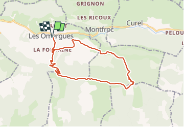
Percorso Sentiero di 16,8 km da scoprire a Provenza-Alpi-Costa Azzurra, Alpes-de-Haute-Provence, Les Omergues. Questo percorso è proposto da phd04.
Descrizione
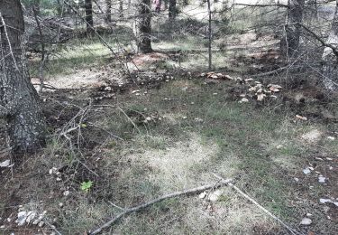
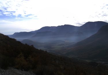
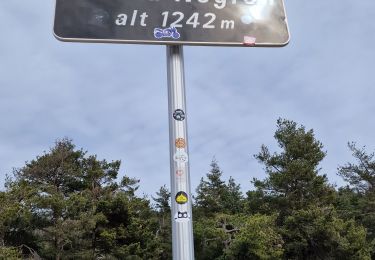
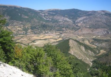
Départ des Omergues. Prendre la direction du Pas de Redortiers par le hameau "Les Fontaines". Une longue piste monte progressivement et vous amènera au sommet (1214 m). Prendre ensuite à gauche la ligne de crête pour rejoindre le Sommet de Larran (1379 m) par le GR de Pays (marquage jaune et rouge). Si vous avez le temps, faites un détour pour aller voir le Jas des Agneaux. Le GR descend jusqu'au col de la Roche (1314 m). Le suivre jusqu'au ravin de Paillar. Vous déboucherez sur une route forestière et là, prendre à gauche jusqu'au hameau de Villevieille. Suivre le PR (jaune) jusqu'au hameau des Fontaines et redescendre aux Omergues.
Localizzazione
Commenti
Percorsi nelle vicinanze
![Percorso Marcia Les Omergues - LES OMERGUES pas de Redortiers . Crêtes de la Faye col de la Roche. Ville o vieille - Photo](https://media.geolcdn.com/t/375/260/ext.jpg?maxdim=2&url=https%3A%2F%2Fstatic1.geolcdn.com%2Fsiteimages%2Fupload%2Ffiles%2F1553511878bg_sport_marche.png)
![Marcia Marcia](https://static1.geolcdn.com/sitytour/trail-icons/101.png)
Marcia
![](/images/other/stat-length.png)
![](https://static1.geolcdn.com/siteimages/upload/files/16400158638029165_repeat_loop_refresh_sync_direction_icon.png)
![Percorso Marcia Séderon - Du Sommet du Négron au Sommet de Larran - Photo](https://media.geolcdn.com/t/375/260/49c6bfc8-8613-4acb-a0dd-7c747ab3c1fb.jpg&format=jpg&maxdim=2)
![Marcia Marcia](https://static1.geolcdn.com/sitytour/trail-icons/101.png)
Marcia
![](/images/other/stat-length.png)
![](https://static1.geolcdn.com/siteimages/upload/files/16400158638029165_repeat_loop_refresh_sync_direction_icon.png)
![Percorso Marcia Montfroc - 720505 - Photo](https://media.geolcdn.com/t/375/260/b23d15a2-fdcf-4624-b2d6-0b11087cf3c9.jpg&format=jpg&maxdim=2)
![Marcia Marcia](https://static1.geolcdn.com/sitytour/trail-icons/101.png)
Marcia
![](/images/other/stat-length.png)
![](https://static1.geolcdn.com/siteimages/upload/files/16400158638029165_repeat_loop_refresh_sync_direction_icon.png)
![Percorso Marcia Les Omergues - Saint André de villeseche. la pyramide du moine - Photo](https://media.geolcdn.com/t/375/260/f0d3a24b-5790-4360-ba83-c34cca9fe40d.jpg&format=jpg&maxdim=2)
![Marcia Marcia](https://static1.geolcdn.com/sitytour/trail-icons/101.png)
Marcia
![](/images/other/stat-length.png)
![](https://static1.geolcdn.com/siteimages/upload/files/16400158638029165_repeat_loop_refresh_sync_direction_icon.png)
![Percorso Marcia Barret-de-Lioure - du col du negron à la pyramide du moine - Photo](https://media.geolcdn.com/t/375/260/1cd7000a-0b07-408e-a63a-e1f455a6250f.jpg&format=jpg&maxdim=2)
![Marcia Marcia](https://static1.geolcdn.com/sitytour/trail-icons/101.png)
Marcia
![](/images/other/stat-length.png)
![](https://static1.geolcdn.com/siteimages/upload/files/16400158638029165_repeat_loop_refresh_sync_direction_icon.png)
![Percorso Corsa a piedi Curel - Les Chaux - Curel - Photo](https://media.geolcdn.com/t/375/260/ext.jpg?maxdim=2&url=https%3A%2F%2Fservices.sitytrail.com%2FGeolivesWS%2FDownloadMedia.ashx%3FTrailID%3D173204%26Media%3D14799_3.jpg)
![Corsa a piedi Corsa a piedi](https://static1.geolcdn.com/sitytour/trail-icons/103.png)
Corsa a piedi
![](/images/other/stat-length.png)
![](https://static1.geolcdn.com/siteimages/upload/files/16400158638029165_repeat_loop_refresh_sync_direction_icon.png)
![Percorso Marcia Curel - Les Chaux - Curel - Photo](https://media.geolcdn.com/t/375/260/ext.jpg?maxdim=2&url=https%3A%2F%2Fservices.sitytrail.com%2FGeolivesWS%2FDownloadMedia.ashx%3FTrailID%3D173203%26Media%3D14799_3.jpg)
![Marcia Marcia](https://static1.geolcdn.com/sitytour/trail-icons/101.png)
Marcia
![](/images/other/stat-length.png)
![](https://static1.geolcdn.com/siteimages/upload/files/16400158638029165_repeat_loop_refresh_sync_direction_icon.png)
![Percorso Marcia Séderon - Autour du col du Negron - Photo](https://media.geolcdn.com/t/375/260/d2519b62-47ac-4bae-a411-e3275e9ce84c.jpg&format=jpg&maxdim=2)
![Marcia Marcia](https://static1.geolcdn.com/sitytour/trail-icons/101.png)
Marcia
![](/images/other/stat-length.png)
![](https://static1.geolcdn.com/siteimages/upload/files/16400158638029165_repeat_loop_refresh_sync_direction_icon.png)
![Percorso Sentiero Les Omergues - t16315-MNT - Photo](https://media.geolcdn.com/t/375/260/a68aee12-4703-4c84-a12c-d2b13c1d04ce.jpg&format=jpg&maxdim=2)
![Sentiero Sentiero](https://static1.geolcdn.com/sitytour/trail-icons/104.png)
Sentiero
![](/images/other/stat-length.png)
![](https://static1.geolcdn.com/siteimages/upload/files/16400158638029165_repeat_loop_refresh_sync_direction_icon.png)